Policy Papers
Measuring Ontario’s Urban-Rural Divide
Weseem Ahmed discusses Ontario’s Urban-Rural Divide.

Summary of Recommendations:
- Recognize that the province’s economic performance is marked by a high degree of regional economic disparity – specifically a growing gap between urban cities and rural towns – and that provincial policies will need to reflect these differences.
- Design a competitiveness strategy for the province rooted in a place-based agenda that aims to bring opportunity and prosperity to all parts of Ontario.
- Leverage the role of post-secondary institutions as catalysts for attracting and developing human capital – including prioritizing the retention of international students in nonurban centres and creating satellite campuses or distance education opportunities for non-urban students.
- Develop cluster strategies for rural economies rooted in their comparative advantages – including natural resources, tourism, and seniors care.
- Target investment attraction programming and activities to bring more foreign direct investment to undercapitalized parts of the province.
- Consider the enactment of tax-based incentives (similar to the U.S. Opportunity Zones model) to pull private capital into undercapitalized parts of the province.
Introduction
Developing a competitiveness strategy for Ontario requires that policymakers understand the differing economic performances and underlying demographic characteristics of the province’s regions. These place-based differences will require that Ontario policymakers draw on different policy levers to support economic activity, investment, and job creation across the province. There are no “one size fits all” solutions in a province with considerable regional economic disparity.
There are big differences between Northern Ontario and the Greater Toronto Area, for instance, and we must understand these differences if we are to develop and implement policies that create the conditions for jobs and economic growth in all parts of the province.
One of the most significant sets of differences in the province is between urban and rural places. The purpose of this short primer is to help Ontario policymakers understand the urban-rural divide in the province – including how it manifests itself in differing economic and social outcomes. The paper concludes with some policy areas that ought to be given consideration as part of an effort to reduce regional economic disparity, and in so doing contribute to bridging the province’s urban-rural divide.
Defining Ontario’s Rural Regions
The first step, of course, is to establish a set of working definitions of urban and rural. The truth is that the question is more complex than one might think. There is no universal definition. Governments and scholars use a combination of metrics – including overall population, population density, and proximity to a major urban centre.
The latter seems particularly relevant for Ontario, where there is a considerable difference between a small town in close proximity to the City of Toronto and a town of a similar size in Northern Ontario that is far from a major economic centre. A place’s position on sliding scale based on its proximity to a major centre is often described as its “rurality.”
Yet, even though the concept of rurality is regularly discussed and debated with clear statistical definitions in academic and policy circles, it is still surprisingly nuanced. Statistics Canada broadly defines a rural area as “any territory lying outside population centres.”[1] That loose definition could characterize various types of places, and its ambiguity offers considerable flexibility to governments and scholars in designing policies or carrying out research.
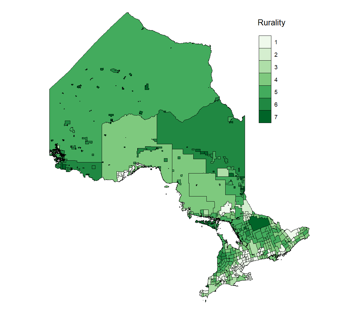
For the purposes of this paper, we have adopted Statistics Canada’s “Statistical Area Classification” methodology for ranking a region’s level of rurality on a scale ranging from one (urban) to seven (rural) (Figure 1). Basically, this methodology arranges places along an urban-rural continuum based on commute times to a major centre.
FIGURE 1: STATISTICAL AREA CLASSIFICATION CODES
A straightforward definition, then, would be to treat the urban-rural cutoff as falling between the third and fourth characteristics in the figure above. This implies that any census subdivision that is not part of a census metropolitan area (CMA) or census agglomeration (CA) will be considered “rural” and the remaining will be treated as “urban.” Applying this methodology to regions across Ontario makes it possible to visualize population centres and their spheres of influence.[2]
We recognize that this approach has its limits. One is that it confines us to using only Census data, which may not contain all the information we are looking for and is bounded by five-year intervals. Another drawback is that, by classifying all CMAs in the same class (i.e., rurality = 1), we treat all Ontarian cities as the same despite the large differences we will demonstrate in later sections.
Nevertheless, the purpose of this paper is to explore the various divides and trends across Ontario’s society and to offer a primer to policymakers on how to address the growing urban-rural divide in the province. For these purposes, the proposed methodology and definitions are adequate.
Ontario divides itself into several distinct regions. Most urban areas are in Southern Ontario along the Highway 401 corridor; they include major population centres such as Ottawa, Kingston, Peterborough, Toronto and the Golden Horseshoe, London, and Windsor (Figure 2). Some exceptions to this rule are Greater Sudbury and Thunder Bay. Beyond these regions the trend is uniform; the degree of rurality increases with isolation. Indigenous reserves are outliers in that many of them that are not part of a CMA are considered rural despite being close to population centres, indicating that people living on reserves tend not to commute to nearby population centres. Simply put, then, most of the province’s urban population is concentrated in a relatively small number of cities in and around the Greater Golden Horseshoe.
FIGURE 2: RURALITY BY CENSUS SUBDIVISION, ONTARIO, 2016
Source: Statistics Canada Boundary Files.
These definitions enable us to track socioeconomic and labour market trends across urban and rural places in Ontario. The next several pages will give readers a sense of how these people and places have performed over time.
I. SOCIOECONOMIC OUTCOMES
Population Growth Trends
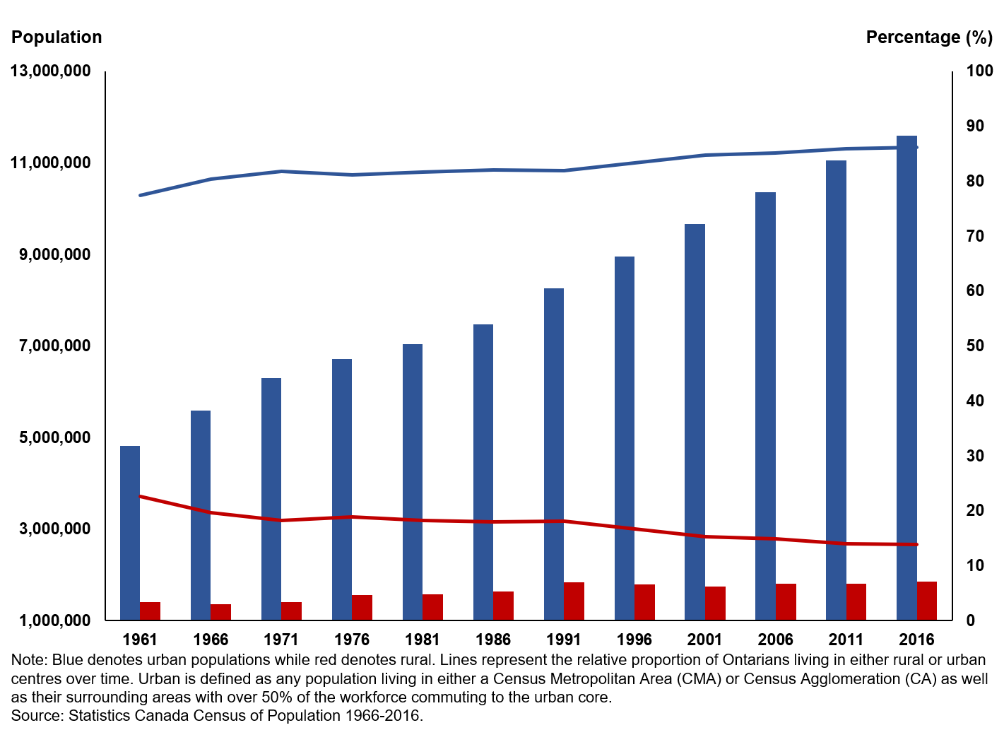
In a broad sense, the population of Ontario, along with its urban and rural areas, has grown continuously over time. Between 1961 and 2016, the province’s urban population increased from nearly 5 million to 11.6 million. Likewise, ruralities have grown steadily from 1.4 million to 1.8 million during that period. What has changed over these years, however, is the relative makeup of the places where people are choosing to live. In 1961, rural Ontarians made up 22.7 percent of the province, a percentage that has consistently declined to 13.8 percent today (Figure 3).
FIGURE 3: ABSOLUTE AND RELATIVE POPULATION CHANGES ACROSS RURAL AND URBAN CENTRES, ONTARIO, 1961–2016
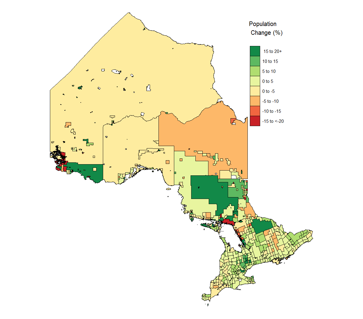
Not all census subdivisions are created equal. Of the 511 CSDs in Ontario for which data exist, 179 saw no or negative population growth between 2011 and 2016 (Figure 4). That means that 35 percent of the province’s cities or towns saw their populations flat-line or actually shrink over this period. The most extreme example was that of the Indigenous reserve called Rat Portage 38A, near the Manitoba border, which lost 65.5 percent of its population in just five years. In fact, the four lowest performances in population growth were all on First Nations reserves. Paradoxically, however, due to their already small populations, some of the fastest-growing CSDs are also Indigenous reserves; even small changes in population appear significant. In general, though, the analysis shows that the greatest population growth took place in urban places. It is a useful guideline that the more urban a census subdivision is, the faster its population growth (Table 1).
FIGURE 4: PERCENT CHANGE IN POPULATION BY CENSUS SUBDIVISION BETWEEN 2011 AND 2016
Source: Statistics Canada 2011 and 2016 censuses.
TABLE 1: POPULATION CHANGE BY DEGREE OF RURALITY OF ONTARIO CENSUS SUBDIVISION, 2011–2016
| Rurality | Population change (percentage) 2011–2016 |
| 1 (most urban) | 5.5 |
| 2 | 0.3 |
| 3 | 2.5 |
| 4 | 1.9 |
| 5 | 0.6 |
| 6 | 0.4 |
| 7 (most rural) | 7.4 |
The Greying of Rural Ontario
We have established that, in general, greater numbers of people are now living in both rural and urban Ontario, even if the growth rate is small in some places. What are the demographic consequences for rural places in which the population is in actual decline? Remember that nearly 200 CSDs shrank between the last two censuses alone. Micro-level decisions have macro effects and, as it turns out, a self-selection bias is fundamentally causing the greying of parts of Ontario.
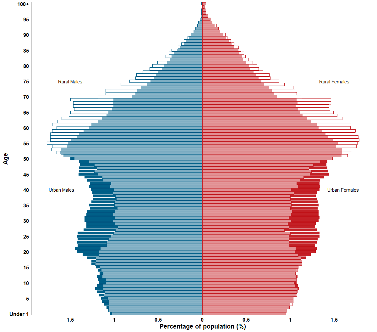
One of the most useful measures for discerning a society’s demographic story is to study its age distribution. The population pyramid below does just that for both urban and rural Ontario. At the low end of the distribution, we see that the relative number of babies and infants is almost identical across Ontario. It does not take long, though, before urban society begins outpacing rural Ontario; the trend is already evident in young children up until the late-teens – especially in boys.
Post-secondary age is the stage at which policy-makers should begin to pay attention: the proportion of working-age Ontarians, both male and female, then becomes much higher in urban centres. It is only after people reach the age of 50 that greater proportions of them are seen in rural Ontario societies than in urban centres, a trend that continues up until the age of 90 and higher. Today, the age divergence has increased such that the median rural Ontarian is six years older than their urban counterpart (Figure 5).
FIGURE 5: RURAL AND URBAN POPULATION PYRAMIDS, ONTARIO, 2016
Source: Statistics Canada, 2016 Census of Population.
These population pyramids are a powerful tool for analyzing the province’s demographics – so much so that it is even possible to see the baby boom beginning with 70-year-olds, coinciding with an uptick in births in 1945 (about 9 months after the end of the Second World War). Interestingly, this baby boom is only pronounced in rural Ontario and has much less influence on urban demographics. This observation strongly suggests that higher proportions of that particular generation are choosing to live outside cities, and that younger people are more likely to self-select into urban environments. Going forward, this trend is likely to continue, for societal and economic reasons that will be explored in the rest of this paper.
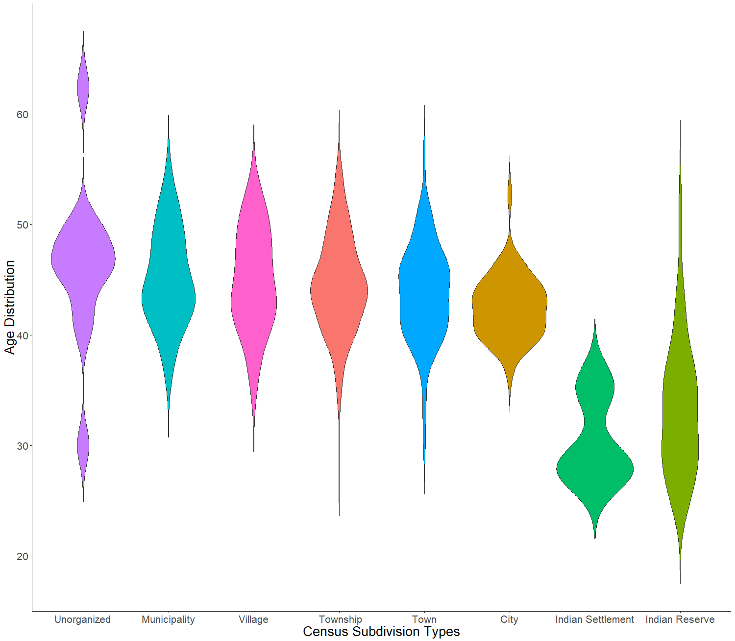
Data also exist to enable an analysis of age distribution across various types of census subdivisions throughout Ontario, irrespective of their urban or rural distinction. The “oldest” census subdivisions, those defined as “unorganized” (in reference to parts of Northern Ontario of Ontario that have no county or regional governments to offer services), have populations averaging 46.2 years of age. Municipalities (small urban centres beyond the influence of a CMA) have the second oldest populations, with an average age of 45.1 years. People in larger cities are significantly younger, averaging 42.5 years. However, the most surprising data are for First Nations reserves and settlements, whose populations average 33.3 and 30.4 years old respectively (Figure 6). It is important to remember that in this case, younger CSDs do not necessarily mean that they are more urban or vice versa, but that these ages represent the average ages of their respective CSD types.
FIGURE 6: AGE DISTRIBUTION OF CENSUS SUBDIVISIONS BY TYPE, 2016
Source: Statistics Canada 2016 Census of Population.
Educational Divergence
As one would expect, the diverging demographics described above are having fundamental impacts on the populations of rural and urban Ontario. The first of these growing gaps is in education.
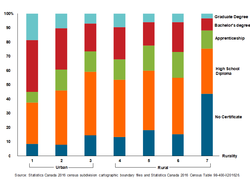
Perhaps unsurprisingly, and for various reasons, the level of education attainment is higher for working-age populations (25–64) in urban places than it is in rural communities. Ontario’s largest urban centres (CMAs) have greater proportions of people with bachelor’s degrees than with only a high school diploma, and twice as many holders of graduate degrees than even smaller urban centres (CAs) – and far more than rural areas. To illustrate the opposite extreme of this point: 55 census subdivisions in Ontario (roughly 12 percent of CSDs) have higher numbers of people who have not graduated from high school than who have earned a high school diploma; 54 of these subdivisions are considered rural (Figure 7).
FIGURE 7: SHARE OF POPULATION BY HIGHEST EDUCATIONAL LEVEL ACHIEVED BY RURALITY, 25–64 YEARS OLD, ONTARIO, 2016
Although this paper draws no conclusion in this regard, we can speculate about the reasons behind this growing educational divide. It is likely driven by two forces: first, the desire on the part of young, ambitious people in rural areas to move to urban centres to pursue higher education; and second, expectations in the labour market that a person with lower credentials can ostensibly find work in a rural economy. Irrespective of the animating factors, a large and growing educational divide between urban and rural places in Ontario is evident, and policymakers will need to take it into account in preparing any rural development strategy. The combination of an aging generation that commands a shrinking portion of the province’s population and a cohort of young people with lower educational achievements (especially in isolated Indigenous communities) will cause innovation to stagnate and economic growth to suffer as a consequence.
In Sickness and in Health
Provincial healthcare spending for 2018–19 is projected to be $61.3 billion, representing an increase of $2 billion from 2017–18.[3] Further, healthcare is projected to be one of the fastest-growing expenses in Ontario’s budget, surpassed only by interest on debt. Between 2017 and 2024, spending on the health sector is projected to rise by 14.5 percent.[4] But what is also of note is that the way these public dollars are spent and the health outcomes they produce are not evenly distributed across the province.
Take the recurring issue of wait times for Ontario health services, for instance. Patient wait times vary greatly across the province but what is interesting is that rural areas are not necessarily worse off. In fact, in some health areas, rural populations face shorter wait times than in urban places.
Consider mental health and addiction services. Wait times can be as short as 19 days for addiction-related treatment in the township of Champlain in eastern Ontario, or as long as 233 days for the same service in the Central West Region (northwest of Toronto). Mental health follows a similar pattern, with wait times for supportive counselling services ranging from eight days in Northwestern Ontario to 287 days in Waterloo-Wellington. For comparison, the provincial average wait times are 58 days for addictions and 53 days for mental health.[5]
Wait times may be comparable among urban and rural places. But the level of health and well-being is certainly better in urban places.
Among ten indicators collected by Public Health Ontario between 2003 and 2017, some give evidence of an improvement in Ontarians’ health in both urban and rural areas (cardiovascular disease), some show no change over time (diabetes), and some show worsening health outcomes (chronic obstructive pulmonary disease). In general, even in cases where hospitalization rates for certain diseases remain constant or are improving, rural areas tend to score worse than their urban counterparts.
Public health units that have a mixture of urban and rural populations tend to have worse health outcomes than areas that are either mostly urban or mostly rural (Figure 8). While it is difficult to pinpoint the exact reasons for this phenomenon, it may have to do with the changing dynamics of mid-tier cities across Ontario, as will be discussed in the next sections of this paper.
FIGURE 8: CHANGE IN AGE-STANDARDIZED CHRONIC OBSTRUCTIVE PULMONARY DISEASE HOSPITALIZATION RATE BY PUBLIC HEALTH UNIT, ONTARIO, 2003 AND 2017
 II. LABOUR MARKET OUTCOMES
Socioeconomic outcomes give us a glimpse into the people who live in Ontario and some of their demographic or social characteristics. In this section, we analyse labour market outcomes to illustrate the ways in which Ontario’s economic performance differs according to place.
An Employment Gap
Between January 2008 and August 2019 (the time of writing), Ontario has added 865,000 new jobs. Overall, this is an impressive performance for employment growth in the province. Yet these gains are hardly uniform provincewide. Many in Ontario feel left out even after the decade-long economic expansion.
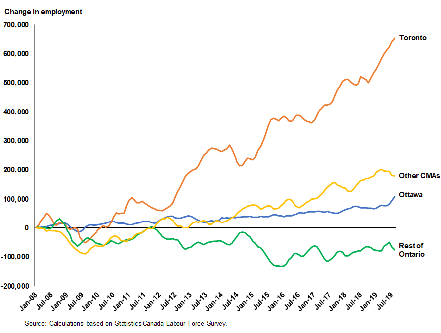
Data from the Labour Force Survey shed some light on this paradox. Of the 865,000 jobs Ontario has generated over this period, 653,000 (75.5 percent) were created in Toronto, 107,600 (12.4 percent) went to Ottawa, and 180,000 (20.8 percent) were in the rest of Ontario’s census metropolitan areas. The parts of Ontario that do not belong to a CMA saw a decline in employment of nearly 76,000 during the same period (Figure 9).
FIGURE 9: CHANGE IN EMPLOYMENT FOR SELECT JURISDICTIONS, ONTARIO, JANUARY 2008–JULY 2019
This concentration of job growth in Toronto and other major centres appears to be affecting labour participation rates. The participation rate – that is, the ratio of employed persons to the working age population (aged 25 to 54) – has been declining since 2006. The implication is that a rising number of working Ontarians are even giving up searching for work.
As a whole, Ontario’s participation rate among those aged 25 to 54 had slowly risen from 1976 until 2003, when it peaked at 87.1 percent; from 2003 until 2018, that rate gradually declined to 85.6 percent. While this may not seem like a big change, it represents a loss of 92,000 workers (if the participation rate had remained at the same level during that fifteen-year period). Naturally, different jurisdictions have different performances when it comes to getting their populations to work. The highest-rated places are Ottawa, Kitchener, Brantford, and Guelph, while former automotive hubs such as London and Windsor are each down by several percentage points.
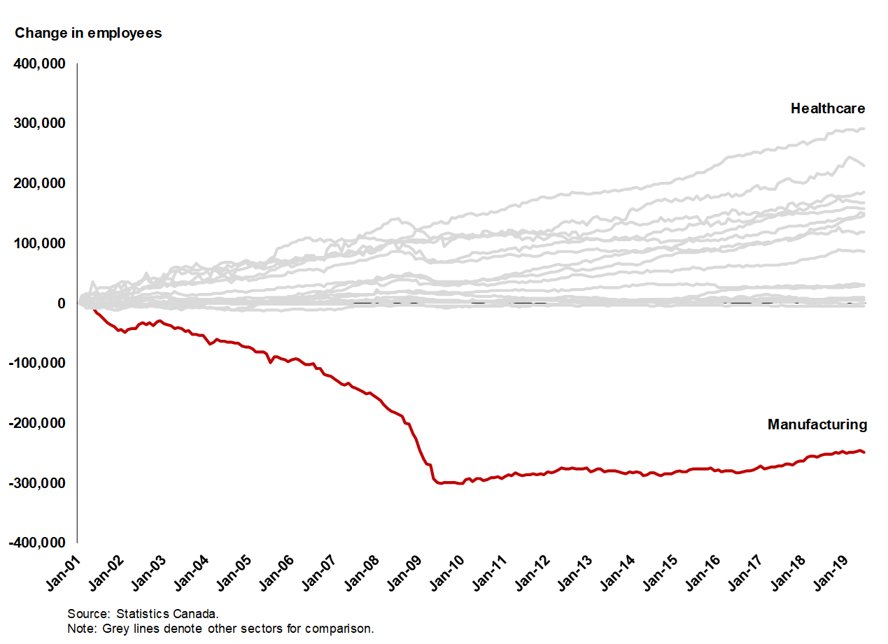
Employment and income growth are partly functions of the changing industrial makeup of the province. The steady decline in manufacturing-based employment is affecting several Ontario places, including Windsor, London, St. Catharines, and Oshawa. As of June 2019, nearly a quarter of a million fewer Ontarians work in the manufacturing sector than did in 2001. For comparison, the healthcare sector saw the largest gains, with over 290,000 new workers (Figure 10).
FIGURE 10: EMPLOYMENT CHANGE BY INDUSTRY, ONTARIO, JANUARY 2001-JUNE 2019
Despite an economy that is in the midst of change, some rural communities are performing reasonably well. Woodstock, a town of 31,000 between Cambridge and London, and ranking three on our rurality scale, for instance, has bucked this trend and managed to bolster its automotive industry by landing Toyota as an anchor and creating dozens of spinoff companies. To accomplish this, they leveraged their position on Highway 401, which is strategically located within a two-hour drive of Michigan, Toronto, and New York State, and a combination of public investments and private incentives.
Smiths Falls, which ranks five on the rurality scale, also has a strategic location. It has used its position between Kingston and Ottawa to generate economic opportunities. A combination of relatively cheap land and proximity to the University of Ottawa and Carleton University in Ottawa and Queen’s University in Kingston has helped to anchor major firms across several industries, including cannabis production. In addition, the city has taken advantage of government programs aimed at promoting economic development from FedDev Ontario, Ontario Centres of Excellence, and the CME SMART Program. As a result, Smiths Falls has within the last decade gone from underperforming the provincial average in terms of employment growth to showing signs of small-town economic success.[6]
Foreign Direct Investment
Nevertheless, the reality for most of Ontario is that geography is destiny; international markets have already come to this conclusion. The shift in the economy’s sectoral composition shown above was mirrored by green-field foreign direct investment (FDI) in Ontario between 2003 and 2017. One of the main results is that investments in manufacturing and mining have fallen by billions of dollars across the provinces and have been replaced by new industries in the services sector, such as real estate, finance, and wholesale trade. Regions that could specialize in these new industries gained in investments that historically may have been distributed elsewhere in the province. Toronto, Kitchener-Waterloo, and Ottawa are winners in this case. Of Ontario’s 49 Census Divisions, 15 received no investments during this period, 12 gained FDI post-2009, and 22 saw a decline in some cases exceeding $3 billion.[7]
There is a sharp disconnect before and after the 2009 recession, but it would be wrong to attribute the urban-rural gap simply to the recessionary effects. The trend is broader and more secular. To the extent that the recession played a role, it is likely more accurate to say that regions that experienced flat-lined or declining FDI after the recession are less competitive than the major urban centres that were able to maintain and even increase their FID intake. The recession, therefore, exposed Ontario’s less-competitive regions of which many – but not all – happen to be rural.
Employment Income Growth
Employment income growth is used to as a proxy for measuring how Ontarians across the urban-rural spectrum are faring with respect to creating employment opportunities for their residents. Employment income is a more useful measure in this regard than total income because total income typically comprises a combination of market income (such as employment income, investment income, and retirement income) and government transfers (such as Employment Insurance, child benefits, and social assistance). Disaggregating income by source is important because, while the composition of one’s income does not matter for the purposes of consumption, it does for measuring one’s participation in work and the broader economy. There is a fundamental difference between income earned through labour activities and income acquired from government transfers. Likewise, we use income data for all employees over age 15, as that will give a better measure of the quality of all jobs generated in the economy as a whole rather than a subset.
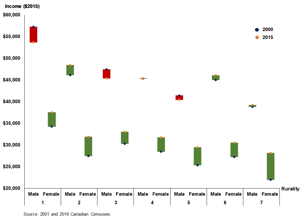
Analyzing employment income data between 2005 and 2015 shows that rurality, or the type of community in which one lives, may play a role in income growth. In general, metropolitans saw the largest drop in income but are still much better off than their more rural counterparts. Census agglomerations earned on average $3,000 more between 2000 and 2015, when accounting for inflation. Smaller towns also saw increases in incomes during this time, except for the most rural areas in Ontario. These increases are led largely by increases in women’s income. Over these 15 years most men saw declines in their income, whereas female workers saw increases regardless of how rural their communities were. On average, women living in Ontario’s most isolated areas earned $6,000 more in 2015 than in 2000. Despite earning less than women in more urban and better-connected areas, women in rural areas experienced the largest increase in incomes between the two censuses. Male incomes across the board largely stagnated or declined during this time (Figure 11).
FIGURE 11: CHANGE IN EMPLOYMENT INCOME BY RURALITY AND GENDER, ONTARIO, 2000–2015
Household Incomes
The income picture across the urban-rural spectrum does not look much better if one adjusts to household incomes. Here, median after-tax household income offers a measure of how middle (50th percentile) “census family” consumption differs across Ontario’s CSDs, after accounting for the impact of government transfers on the income of all its family members.[8] Census subdivisions that are a part of a CMA have higher incomes than places that are further from major centres. Household incomes continue to drop with increased rurality, with isolated CSDs – usually First Nation reserves – performing the worst. This disparity has exacerbated regional-based income inequality within the province: households in the wealthiest CSD, which is Oakville, bring in nearly four times the annual income of the median household in Wabaseemoong, the poorest area of Ontario (Figure 12).
FIGURE 12: MEDIAN HOUSEHOLD AFTER-TAX INCOMES BY RURALITY, ONTARIO CENSUS SUBDIVISIONS, 2016
Source: Statistics Canada 2016 Census and census subdivision boundary files.
Note: Each dot represents a census subdivision.
Inequality in Ontario, of course, goes beyond the rural-urban split. There exists a large disparity between high- and low-income households within classifications of rurality, even after accounting for after-tax income which adjusts for a combination of tax and transfer payments. Many of the poorest CSDs, regardless of their proximity to urban centres, are First Nation reserves, and it appears that simply being near a CMA has little economic benefit to these communities. On the opposite end, many of Ontario’s top CSDs in terms of household income are those clustered around the Greater Toronto Area (GTA) such as Oakville, King, Mono, and Caledon. As a result, the province’s after-tax Gini Coefficient, which measures income disparity, is the highest among provinces in Canada at 0.322 compared to the national average of 0.309.[9]
Social Mobility
One measure of a place’s vitality and optimism is its capacity for social mobility, which is the basic idea that a child has the possibility of earning more than his or her parents. Ontario’s overall record on social mobility is reasonably positive. But urban and rural differences also exist.
A study by economist Miles Corak investigates various aspects of social mobility across Canada for generations born between 1963 and 1970 and their children. In Ontario, all 49 census divisions saw an increase in a child’s average household income relative to his or her parents.[10] Timiskaming District (rurality 7) saw the largest of these increases ($19,675), followed by Perth County (rurality 3 to 5) at $19,482, and Huron County (rurality 5 to 6) at $18,809. Thunder Bay District saw the smallest intergenerational gain at just $5,928.
Relative income mobility provides a metric for measuring economic well-being. This metric measures how a child’s income changes in relation to his or her parent’s income and aims to get at the question of how income inequality may be transmitted to future generations. In Toronto, for instance, for every one percent increase in a parent’s income, their children can expect on average a 0.19 percent increase in their own income (which also happens to be the Ontario average). Interestingly, this income elasticity is higher in regions with lower children’s incomes. Kenora and Manitoulin districts (rurality 6 to 7) have the highest elasticities in the province, but in turn have among the lowest incomes for children. At the other end of the spectrum, Dufferin County, which happens to be the wealthiest CD with a mean child income of $55,657, has the lowest income elasticity, with an increase of only 0.092 percent for every percent a parent’s income goes up.
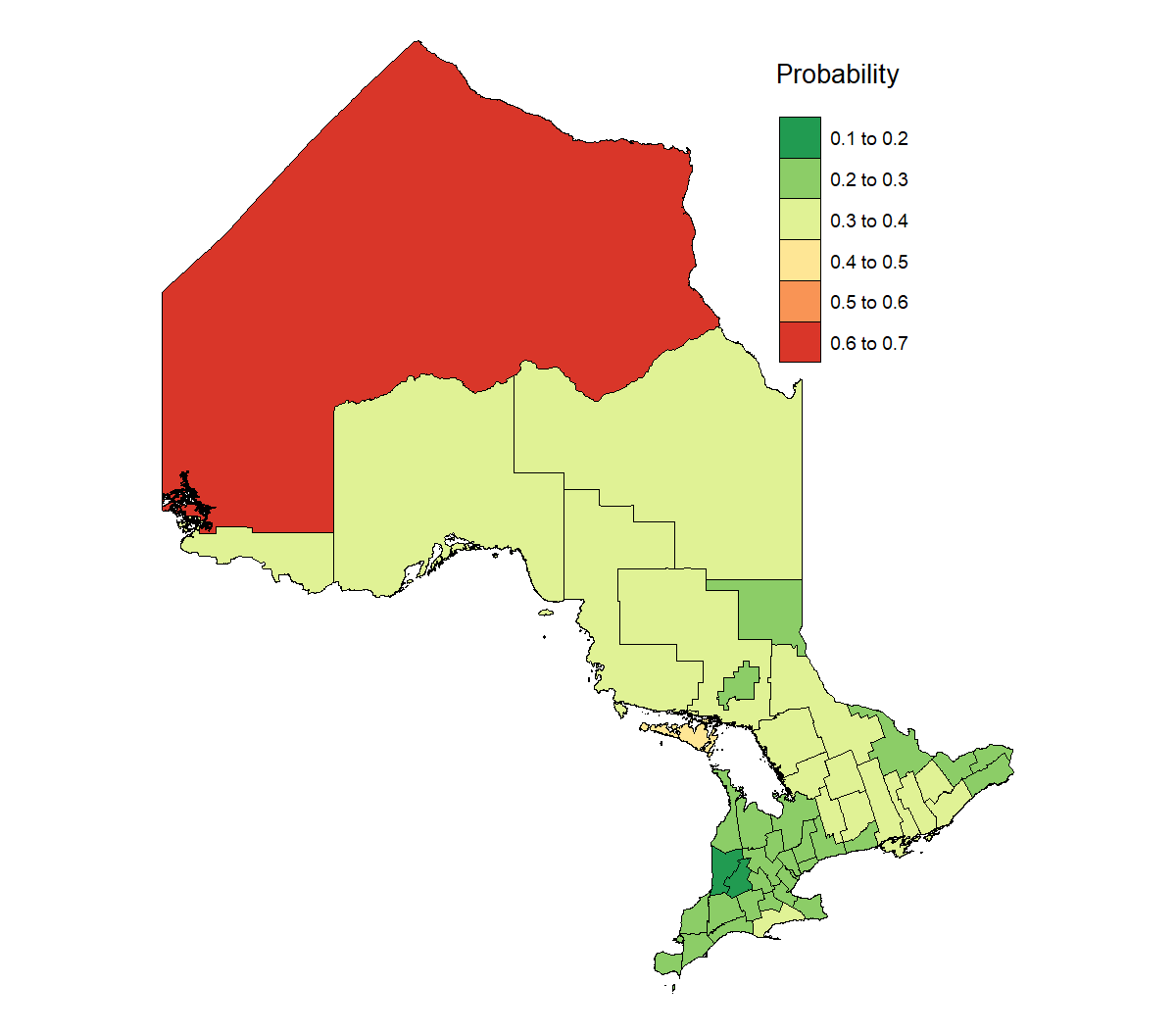
Rising incomes do not always equate with rising opportunities. While it is good that incomes are increasing generationally, the true measure of mobility is the ease with which those raised in the bottom of the distribution can rise to the median and the extent to which that is correlated to geography. To measure this, Corak studies three different metrics: cycle of low income, so-called “rags to riches,” and cycle of privilege. The cycle of low income, or the probability of a child raised by parents in the bottom 20 percent remaining in the bottom quintile, is of importance. Ideally, with effort and determination, someone born in the bottom quintile should be able to improve their rank relative to other Canadians. If not, then that would suggest that geography is a predictor of future success.
The average Ontarian born to parents who are in the bottom 20 percent of Canadian income earners has a 28.4 percent likelihood of also becoming a bottom-quintile adult. This is a lower probability than the Canadian average (30.1 percent), but the inter-regional differences show a stark contrast. At the low end, children in low-income Perth and Huron counties have respectively only a 19.3 and 19.5 percent likelihood of remaining low-income adults – better than a random draw. For comparison, Toronto, where by far most children live, has a 28.9 percent likelihood. The real issue, however, is with Manitoulin and Kenora districts, where they have a 49.5 and 61.6 percent likelihood respectively of remaining low-income – a worse outcome than flipping a coin (Figure 13).
FIGURE 13: PROBABILITY OF A CHILD BORN INTO A BOTTOM-QUINTILE HOUSEHOLD REMAINING IN THE BOTTOM QUINTILE AS AN ADULT, ONTARIO CENSUS DIVISIONS
 Source: Miles Corak (2017). “Divided Landscapes of Economic Opportunity: The Canadian Geography of Intergenerational Income Mobility.” University of Chicago, Human Capital and Economic Opportunity Working Paper Number 2017-043.
At the other end of the distribution, for the top 20 percent, there is also stickiness across all of Ontario’s CDs. This means that children born to parents in the top quintile are more likely to become top-quintile adults themselves across every census division in the province. However, the rates are not evenly distributed. Manitoulin District had the second worse outcomes for children born into the bottom quintile and is also the CD where children who are born into the top are least likely to remain there, with odds slightly better than random at 23.9 percent. Toronto comes out on top, with wealthy children having a 40.2 percent chance of being wealthy adults. Halton (38.8 percent), Ottawa (38.4 percent), and York Region (37.9 percent) trail closely behind. For comparison, the provincial average is 31.5 percent.
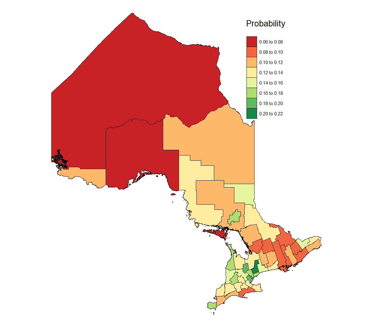
What do these two features mean for Ontario? On one hand, it is advantageous for the province to be a place where geography is not destiny and a child born anywhere has the same chance as everyone else to move up the social mobility ladder. But this is a zero-sum game; for every percentile one child moves up, another child must go down a percentile. To what degree, therefore, should geography play a role in determining the next generation’s outcome? In other words, we need to know how easy it is for children born into low-income families to move up to a higher quintile. The average Ontarian born to a family in the bottom quintile has a 14.1 percent chance of making it to the top quintile. Those odds are elevated in York Region (20.5 percent), Dufferin County (19.5 percent), and Halton (19.4 percent). The least likely places for a child to make this jump are Thunder Bay District (7.8 percent), Manitoulin District (7.4 percent), and Kenora District (6.8 percent) (Figure 14).
FIGURE 14: PROBABILITY OF A CHILD BORN INTO A BOTTOM-QUINTILE HOUSEHOLD MOVING TO THE TOP QUINTILE AS AN ADULT, ONTARIO CENSUS DIVISIONS
Source: Miles Corak (2017). “Divided Landscapes of Economic Opportunity: The Canadian Geography of Intergenerational Income Mobility.” University of Chicago, Human Capital and Economic Opportunity Working Paper Number 2017-043.
Policy Recommendations
Many factors contribute to the demographic and economic underperformance of parts of rural Ontario. Many of these forces transcend the role of government and public policy. They reflect broader global trends and the market’s efficient allocation of resources. It would be a mistake to assume that public policy can deliver full economic parity.
But that does not mean that government has no role in addressing the underperformance of rural areas with respect to intergenerational mobility, educational attainment rates, and investment and employment. One option is to examine the advantages that urban areas have and try to replicate some of them in rural and remote areas. Think of it as an agenda to try to level the playing fields across regions and places.
Create poles of growth through higher education
One of Southern Ontario’s greatest strengths is undoubtedly what Corak refers to as “poles of growth” – that is, regions that facilitate upward mobility. In Ontario, these poles are found near urban centres and so give the impression that the divide between urban and rural is endogenous and cannot be bridged. This is of course untrue, as there are rural regions in Alberta and Saskatchewan that also act as poles of growth and produce some of the highest rates of social mobility in Canada. Ontario’s poles of growth have even been influential enough to overcome shifts in the economy and the loss of manufacturing jobs that once characterized much of Southwestern Ontario.
At the centre of these poles are robust post-secondary institutions. Ontario’s 21 universities and 24 colleges are educating over 500,000 students, even as the economy’s sectoral composition changes. However, the fact that most of these institutions are in the south or near major population centres in the north makes it convenient for students in urban centres to invest in an education but greatly increases the social or economic cost for northern students. In addition, university or college towns benefit from the spillover effects of simply having a higher institution.
To have a sense of how higher education can benefit a region, Professor Mike Moffatt from the Ivey Business School has said: “London [Ontario] has gone from plant closure to plant closure, and you get to tens of thousands of jobs lost with little difficulty. One thing that has helped save London from the fate of some rust-belt cities is the presence of the local university.”[11] The municipality of Chatham-Kent provides a glimpse of what London could have been without Western University. Correspondingly, to expand educational offerings either through physical campuses or remote learning could help lower the cost of education for northern Ontarians and generate more poles of growth in the north.
Ontario’s policymakers should therefore come to see a role for post-secondary institutions in place-based economic strategies. Opportunities exist, for instance, to leverage the human capital of international students as prospective permanent residents for communities facing population challenges and needing talented, dynamic, and entrepreneurial people to catalyse innovation and growth.
Clustering talent
Ontario’s rural regions suffer from a lack of competitiveness in comparison to urban centres. That difference is obvious and is a major source of the differing economic outcomes ranging from wages to foreign investment.
A theory that has been studied in other parts of the world but less so in Canada is that the agglomeration of people, industry, and academic institutions creates positive spillover effects that enhance a region’s or a city’s competitiveness. This has been true for Ontario’s former manufacturing sector and in more recent successes such as Toronto’s Financial District and the Toronto-Waterloo tech corridor.
Urban centres have embraced these agglomeration effects much more readily than rural centres and so have seen steady growth over decades. Rural areas must now adopt clustering in accordance with their specialties and comparative advantages in order to expand local economies. These advantages can come in the form of central localization, access to minerals and resources, abundance of cheap land, and even the exploitation of a region’s local branding.
Woodstock and Smiths Falls are examples of localities that have taken advantage of their locations to attract anchor firms; Attawapiskat and other northern, Indigenous communities have at one point attracted billions of dollars of investment in their mineral deposits; many parts of the Toronto area, especially outside the GTA, have access to abundant and affordable land that can be used for industry or “retirement villages”; and finally, Stratford and Muskoka are two rural areas that have used their branding to attract tourists and sell speciality products highlighting theatre and scenic beauty respectively.
Whereas the benefits of clustering have accrued to urban jurisdictions mostly through market forces, at the local level in rural parts of the province they will need to be catalyzed by government. It will also be important to target regions on the basis of their underlying strengths and weaknesses rather than apply a “one size fits all” approach. Much of this research on clustering and approaches to its effective implementation has been analyzed by the former Institute for Competitiveness & Prosperity.[12]
Opportunity zones model
As another Ontario 360 paper observes, the American government is experimenting with a series of tax preferences to encourage investment in undercapitalized communities across the country. The Tax Cuts and Jobs Act of 2017 enacted a new Opportunity Zones model that provides tax preferences related to capital gains for investors who deploy their capital to roughly 8,700 opportunity zones selected on the basis of their economic underperformance relative to the national average.
Currently, Ontario offers region-specific funding for different parts of the province in the form of direct-spending grants and loan programs. Rural and Northern Ontario are included through the Rural Economic Development Fund and Northern Ontario Heritage Fund Corporation programs. However, there is no tax-based advantage to investing in rural or northern regions of the province. It may be worth exploring how the Opportunity Zones model may translate to the Ontario context, given that it is more neutral and less interventionist than the current direct-spending programs operated by the province. A uniquely “made in Ontario” place-based incentive program that can address some of the potential issues faced by the American version (namely, the extension of tax preferences to parts of a census tract that may not be underperforming) may be a useful tool for catalysing economic activity in distressed parts of the provinces.
Conclusion
As part of a competitiveness strategy for Ontario, the province’s policymakers are going to need to be cognizant of growing regional economic disparity and in turn develop policies that address opportunities and challenges in all parts of the province. Progress on leveling the economic playing field between urban centres and rural areas will need to be a key part of that agenda. This paper provides an empirical basis to aid policymakers in moving ahead.
Author Bio
Weseem Ahmed was a policy analyst at the former Institute for Competitiveness & Prosperity where he studied various economic policy and competitiveness issues including the urban/rural divide in Ontario. He is currently a research associate at an upstart policy think-tank focused on climate change. Ahmed has a Master’s degree from the Toulouse School of Economics.


